


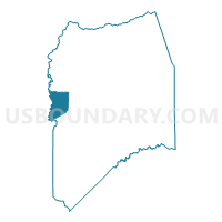
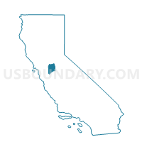
Voting District 30921, San Joaquin County, California
About
Outline

Summary
| Unique Area Identifier | 542287 |
| Name | Voting District 30921 |
| County | San Joaquin County |
| State | California |
| Area (square miles) | 32.87 |
| Land Area (square miles) | 30.70 |
| Water Area (square miles) | 2.17 |
| % of Land Area | 93.39 |
| % of Water Area | 6.61 |
| Latitude of the Internal Point | 37.92576270 |
| Longtitude of the Internal Point | -121.52802560 |
Maps

Graphs
Select a template below for downloading or customizing gragh for Voting District 30921, San Joaquin County, California


Neighbors
Neighoring Voting District (by Name) Neighboring Voting District on the Map
- Voting District 30920, San Joaquin County, CA
- Voting District 30926, San Joaquin County, CA
- Voting District 31095, San Joaquin County, CA
- Voting District 32890, Contra Costa County, CA
- Voting District 32980, Contra Costa County, CA
- Voting District 33005, Contra Costa County, CA
Top 10 Neighboring County Subdivision (by Population) Neighboring County Subdivision on the Map
- Stockton CCD, San Joaquin County, CA (343,203)
- East Contra Costa CCD, Contra Costa County, CA (119,315)
Top 10 Neighboring Place (by Population) Neighboring Place on the Map
Top 10 Neighboring Elementary School District (by Population) Neighboring Elementary School District on the Map
- Byron Union Elementary School District, CA (14,957)
- Knightsen Elementary School District, CA (2,470)
Top 10 Neighboring Secondary School District (by Population) Neighboring Secondary School District on the Map
Top 10 Neighboring Unified School District (by Population) Neighboring Unified School District on the Map
Top 10 Neighboring State Legislative District Lower Chamber (by Population) Neighboring State Legislative District Lower Chamber on the Map
Top 10 Neighboring State Legislative District Upper Chamber (by Population) Neighboring State Legislative District Upper Chamber on the Map
- State Senate District 5, CA (1,032,613)
- State Senate District 14, CA (1,020,927)
- State Senate District 7, CA (947,426)
Top 10 Neighboring 111th Congressional District (by Population) Neighboring 111th Congressional District on the Map
Top 10 Neighboring Census Tract (by Population) Neighboring Census Tract on the Map
- Census Tract 3040.05, Contra Costa County, CA (6,738)
- Census Tract 3040.03, Contra Costa County, CA (3,433)
- Census Tract 39, San Joaquin County, CA (1,749)
- Census Tract 3040.02, Contra Costa County, CA (1,426)